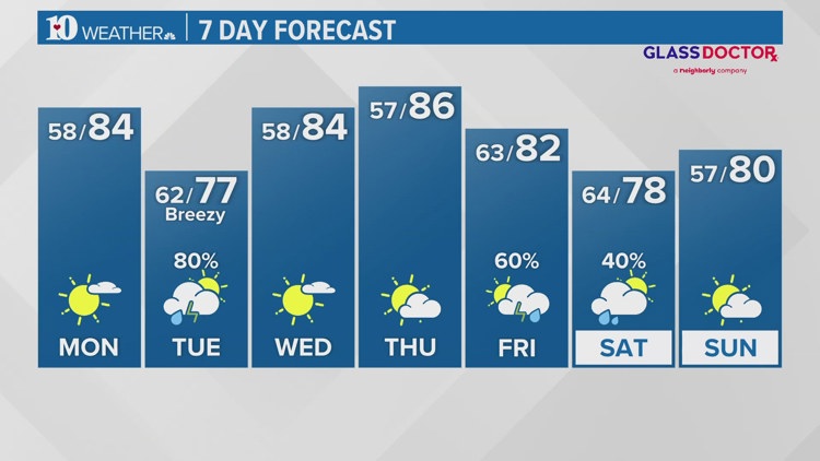
WBIR Forecast
Weather News
- Showers & storms to move in before sunrise Tuesday
- Tornadoes kill 4 in Oklahoma; governor issues state of emergency for 12 counties amid power outages
- New color-coded heat risk tool adds a level higher than red
- Strawberry season is ripe for the picking!
- Lyrid meteor shower: When is the peak, where to look in the sky
- Great American Eclipse turns out no-so-great for cloud-covered East Tennessee
10-Day Forecast
Mon
Apr 29
84
62
0%
9
MPH
SW
More sun than clouds. Highs in the low 80s and lows in the low 60s.
55%
Very High
6:44 AM
8:21 PM
Tue
Apr 30
77
58
80%
6
MPH
SW
Showers and thunderstorms. Highs in the mid 70s and lows in the upper 50s.
77%
Moderate
6:43 AM
8:22 PM
Wed
May 01
84
57
0%
3
MPH
NNE
Mix of sun and clouds. Highs in the low 80s and lows in the mid 50s.
64%
Very High
6:42 AM
8:23 PM
Thu
May 02
86
63
0%
3
MPH
NNW
A few clouds. Highs in the upper 80s and lows in the upper 50s.
52%
Very High
6:41 AM
8:24 PM
Fri
May 03
82
64
60%
7
MPH
SW
Chance of afternoon showers. Highs in the low 80s and lows in the low 60s.
59%
High
6:40 AM
8:24 PM
Sat
May 04
78
57
40%
6
MPH
WSW
Scattered thunderstorms possible. Highs in the low 80s and lows in the upper 50s.
68%
High
6:39 AM
8:25 PM
Sun
May 05
80
61
0%
6
MPH
WSW
Showers possible in the afternoon. Highs in the upper 70s and lows in the low 60s.
66%
High
6:38 AM
8:26 PM
Mon
May 06
79
61
50%
7
MPH
WSW
Scattered thunderstorms possible. Highs in the upper 70s and lows in the low 60s.
69%
High
6:37 AM
8:27 PM
Tue
May 07
79
60
40%
8
MPH
WSW
Afternoon thunderstorms. Highs in the upper 70s and lows in the low 60s.
68%
Very High
6:36 AM
8:28 PM
Hourly Forecast
4 AM
Mon
61°
0%
7
MPH
SSW
5 AM
Mon
61°
0%
6
MPH
SSW
6 AM
Mon
60°
0%
6
MPH
SW
7 AM
Mon
58°
0%
4
MPH
SW
8 AM
Mon
61°
0%
5
MPH
SSW
9 AM
Mon
65°
0%
6
MPH
SSW
10 AM
Mon
69°
0%
8
MPH
SSW
11 AM
Mon
72°
0%
7
MPH
SSW
12 PM
Mon
75°
0%
7
MPH
SW
1 PM
Mon
77°
0%
8
MPH
SW
2 PM
Mon
78°
0%
9
MPH
SW
3 PM
Mon
79°
0%
10
MPH
SW